All you need to know about “Nepal EBC Trek Map”
Here is a brief description of the Everest Base Camp (EBC) trek map in Nepal:
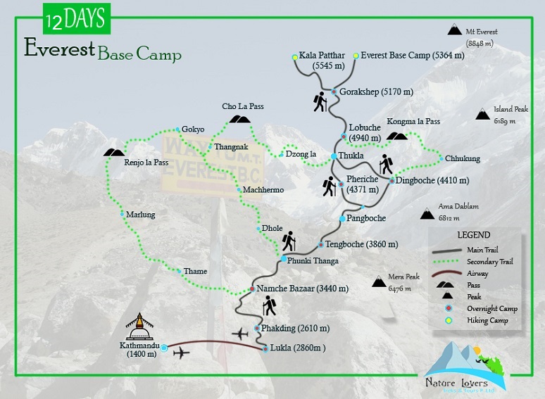
The Everest Base Camp trek is one of the most iconic and challenging treks in Nepal. It takes you to the base camp of Mount Everest, the highest peak in the world. The trek begins from Lukla, a small town in the Khumbu region, and follows a well-established trail through various Sherpa villages, high-altitude passes, and breathtaking mountain landscapes.
The EBC trek map starts from Lukla, a small town in the Solu-Khumbu region of Nepal, and extends all the way to Everest Base Camp. Lukla is the starting point for most trekkers as it has a small airport that connects to Kathmandu. The map typically outlines the trekking route, highlighting important landmarks, villages, and rest stops along the way.
From Lukla, trekkers begin their journey by following the Dudh Koshi River. The trail gradually ascends through picturesque villages like Phakding and Monjo, where trekkers can witness traditional Sherpa culture and hospitality. The map showcases these villages, allowing trekkers to understand their location and progress along the trail.
As trekkers continue their ascent, they reach Namche Bazaar, a vibrant trading hub and the gateway to the Khumbu region. The map highlights Namche Bazaar as a crucial rest and acclimatization point. It is an ideal spot to explore the surrounding area, interact with locals, and enjoy stunning views of Everest and its neighboring peaks.
From Namche Bazaar, the trail proceeds to Tengboche, home to the famous Tengboche Monastery. The map indicates the location of the monastery, allowing trekkers to plan a visit and witness the serene atmosphere and panoramic mountain vistas. The trail then leads to Dingboche and Lobuche, passing through diverse landscapes, including alpine forests, suspension bridges, and open valleys.
As trekkers approach higher altitudes, the map highlights the presence of acclimatization stops such as Dingboche and Lobuche. These rest days are essential to adapt to the thinning air and prevent altitude sickness. The map can help trekkers plan their itinerary accordingly, ensuring a safe and enjoyable journey.
From Lobuche, trekkers make their way to Gorak Shep, the last village before reaching Everest Base Camp. The map showcases the challenging section from Gorak Shep to the base camp, which involves traversing glacial moraines and rocky terrain. This stretch can be physically demanding but rewards trekkers with the incredible experience of standing at the base camp of the world's highest peak.
In addition to Everest Base Camp, many trekkers also ascend Kala Patthar, a prominent viewpoint located above Gorak Shep. The map highlights the trail to Kala Patthar, enabling trekkers to navigate their way to this vantage point. From the summit of Kala Patthar, trekkers can enjoy panoramic views of Everest, Lhotse, Nuptse, and the surrounding Himalayan peaks.
The EBC trek map also indicates the altitudes at different points of the trail. This information helps trekkers track their elevation gain and plan their acclimatization strategy accordingly. It serves as a useful tool to monitor altitude sickness symptoms and ensure a gradual ascent to minimize risks.
Along the trail, the map showcases the availability of teahouses, lodges, and villages where trekkers can find accommodation and meals. These establishments provide a cozy place to rest, enjoy warm meals, and interact with fellow trekkers from around the world. The map can assist in identifying suitable resting spots for overnight stays.
The EBC trek map is an essential resource for trekkers, providing a visual guide to the entire route. It assists in navigation, allows trekkers to anticipate upcoming challenges, and helps them make informed decisions about their trekking itinerary. While it is important to rely on experienced guides and local knowledge, having a detailed map can enhance the overall trekking experience in the stunning Everest region of Nepal.


.jpg "Visa Card")


